Have you been in a situation where your client requests changes to their Traffic Impact Assessment (TIA) after you have completed it, then dread the amount of work it’ll take to make 3 simple changes within the Trip Generation piece only?
The top items that generally get changed are typically due to public consultation or zoning by laws that pertain to changes in:
- The timing of the project: can get pushed ahead or get delayed; and/or
- Additional land uses: including a different land use, or replacing an existing; and/or
- The size of the development: add or reduce to the sq ft of the building
When working with a TIA there will likely be times you will need to make these changes. Perhaps these changes are caused by a dissatisfied approving authority because the development does not align with their new or updated masterplan, or your client has modified the development.
At Transoft Solutions, we understand using traditional methods for changes is not easy. Thankfully, with OTISS Pro you can make simple changes to your analysis so that you do not dread the next call from your client.
Changes in timing of the project
When the timeline of the project changes, the updating of the horizon year plays a huge factor in forecasting future traffic. The horizon year in a TIA indicates the farthest future year that will be considered when creating your analysis. The number of specified years is also dependent on the size of the development and the types of land uses.
You may run into a situation where your client will need to change their horizon year. OTISS Pro allows this adjustment to be done in only a few simple steps. This section will show you the growth or decline in traffic by comparing it to counts from previous years. Because growth rates are quite advanced, different growth rates will be used for different developments in order to simulate accurate traffic. Once you apply the changes, the assessment will adjust to your new horizon years.
One way this can be done is by making changes directly in the Scenario Summary page by editing your scenario and adjusting the numbers in the given pop-up.
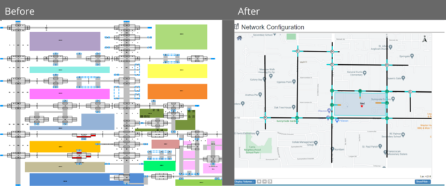
Alternatively, you can change your horizon year directly in the Network Configuration of your assessment. By clicking on an intersection leg, you can navigate to the % Growth Over the # of Years.
Adding additional land uses
Transportation and land use planning relationships are complex, with various interactive effects which can significantly impact the traffic within your network. Therefore, affecting the approval process of the development proposal.
Different land use patterns have different accessibility features. Urban areas have more accessible land use and more diverse transport systems, but slower and more costly automobile travel. Suburban and rural areas have less accessible land use and fewer travel options, but driving is faster and cheaper per mile.
It is therefore important to be able to analyze multiple land uses so individual decisions support strategic goals.
Within OTISS Pro, you can add a new land use to your project in a matter of minutes. On the Trip Generation page, you can:
- Add a new row and input your new land use
- Adjust your time periods to match your other land uses
- Review and update the entry and exit points for your multi-modal adjustments
- Assign a driveway and input the percentages of your inbound and outbound trips, as needed
- Pass by trips will be automatically updated
Changing or adding additional land uses and the other points above will make a significant difference to your assessment. Your land use is linked to your distribution and assignment, so an office would have a higher inbound traffic in the morning whereas a residential use would be the opposite. Therefore, adjusting the time-period will create a more accurate assessment because everything is connected to your distribution and assignment, reviewing and updating the entry and exit points for your Multi-Modal Adjustments and Internal Capture will account for all modes of transportation resulting in an even more detailed report.
Finally, your pass by trips will also be affected because there will be additional traffic when adding a new land use. For example, if you are adding a commercial or retail development this will increase the attraction of traffic from an adjacent road.
Changing the size of the project
When the size of development needs an update, that means the land intensity of your assessment needs an adjustment.
Making changes to your intensities will have an affect on your vehicle trips; therefore, you will need to go through your Internal Capture Analysis and ensure it is accurate.
Depending on if the size of your intensity is increasing or decreasing your vehicle trips will also be higher or lower. An increase in your vehicle trips will result in more traffic meaning that there may be additional costs to your development such as bigger roads or a new light signal.
You can change the intensity in OTISS Pro on the Trip Generation page by editing your size.
Completing the TIA & Benefits
Once all the above is updated accordingly within OTISS Pro, you’ll wonder why you ever used a spreadsheet for all these calculations before.
Changes used to be time consuming and costly when using spreadsheets. Now you can rest easy knowing that OTISS Pro revolutionized the old methods of building street models and using formulas in spreadsheets.
Make the required changes hassle free and the new data and turning volume movements (TVM) will be instantly calculated all in one place. Easily support your client’s request and present the alternative figures in your assessment in a fraction of the time.
And to top it off with a cherry, you can also seamlessly export the analysis (Network and Turning movement) into Synchro.
Ready to see it in action? Try it today.