By simplifying and streamlining information sharing, the AeroCENTRAL platform reduces duplication and ensures everyone has easy access to the most current airside operations information.
A new collaborative, cloud-based platform created by Transoft Solutions has the potential to transform the way airports around the world use and share airside operations information. AeroCENTRAL, along with the applications that run on the platform, combines an airport’s infrastructural information, such as its design and technical documents, with operational data in a centralized user-friendly interface.
This essential information, such as the latest aircraft parking stand configurations, equipment locations and turnaround procedures, can then be easily viewed, used, and shared on any internet-connected device — supporting operators, airlines, ground handlers, and other stakeholders in safer and more efficient airside operations.

Figure 1. The AeroCENTRAL platform
“A lot of effort and expense goes into designing airside infrastructure,” says Bernard Goodworth, Senior Product Manager at Transoft. “Airports also invest a lot of time and money into maintaining and improving their airside infrastructure. For the design engineer, the process ends with the construction drawings; for the civil engineer, it ends with construction completion; for operations, it never ends. You can never be sure that the culminated intention of the design and construction process reaches operations in a usable form, for continued use.”
After construction is complete, the operations department typically takes over responsibility for managing and working with the infrastructure. As-is drawings, which are usually created using highly technical CAD software, are often made available, but converting them into usable working documents to be used in daily operations can be challenging. This often leads to an additional, very cumbersome, process of extracting the non-technical from the technical data and combining that with operational procedure data to create a workable (single source) guideline for all airside stakeholders.
With AeroCENTRAL’s Stand Guide application which, along with the platform’s Specifications application, was made available at launch, critical parts of the technical design documents, for example aircraft parking plans and lead-in and pushback simulations from Transoft’s AviPLAN application, can be quickly transferred to a navigable mapping environment, making them easily accessible across the board. This means that operational users can view high-quality, accurate models of airside areas like aprons and stands, as well as accurate aircraft characteristics, in a non-technical system, alongside any other information they need to do their jobs.

Figure 2. The AeroCENTRAL Stand Guide application
Most people have experience with web-based map navigation these days, so AeroCENTRAL Stand Guide is quick and easy for users to master. The flexibility of the system allows the administrator to couple whatever information is needed, right where it’s needed. For example, an aircraft parking stand’s status can be set to show if it is active or inactive, and stand adjacency dependencies are calculated on the fly, meaning they are always up to date. Further, if a particular aircraft is not cleared to use a stand, perhaps due to operational reasons, this information can be easily added as well.
Because AeroCENTRAL is cloud-based, it can be readily accessed from any device, anywhere. At the same time, the information the Stand Guide applications delivers can be set so that specific users see only the information that is relevant to them. “It’s been designed so it’s possible to develop a complex matrix of user personas and access levels. Someone who loads baggage will likely need quite limited information. So, they can get just that. They don’t have to browse through any unnecessary information” says Goodworth.
Within AeroCENTRAL Stand Guide, information is also automatically filtered as users navigate. Goodworth continues, “For example, if you are looking at the overall airport, you’ll only get general information about the airport, such as the total number of aprons and stands. If you then go to a particular apron area, you’ll get a different level of information about what happens on that smaller area, such as a list of stands, conditions for stand use, equipment storage and staging, specific procedures for bus boarding or passenger movement control. And when you navigate to a single stand, again you get a different level of information. At this level, users can even benefit from a live link to the Specifications application, which adds a whole new layer of possibilities.”
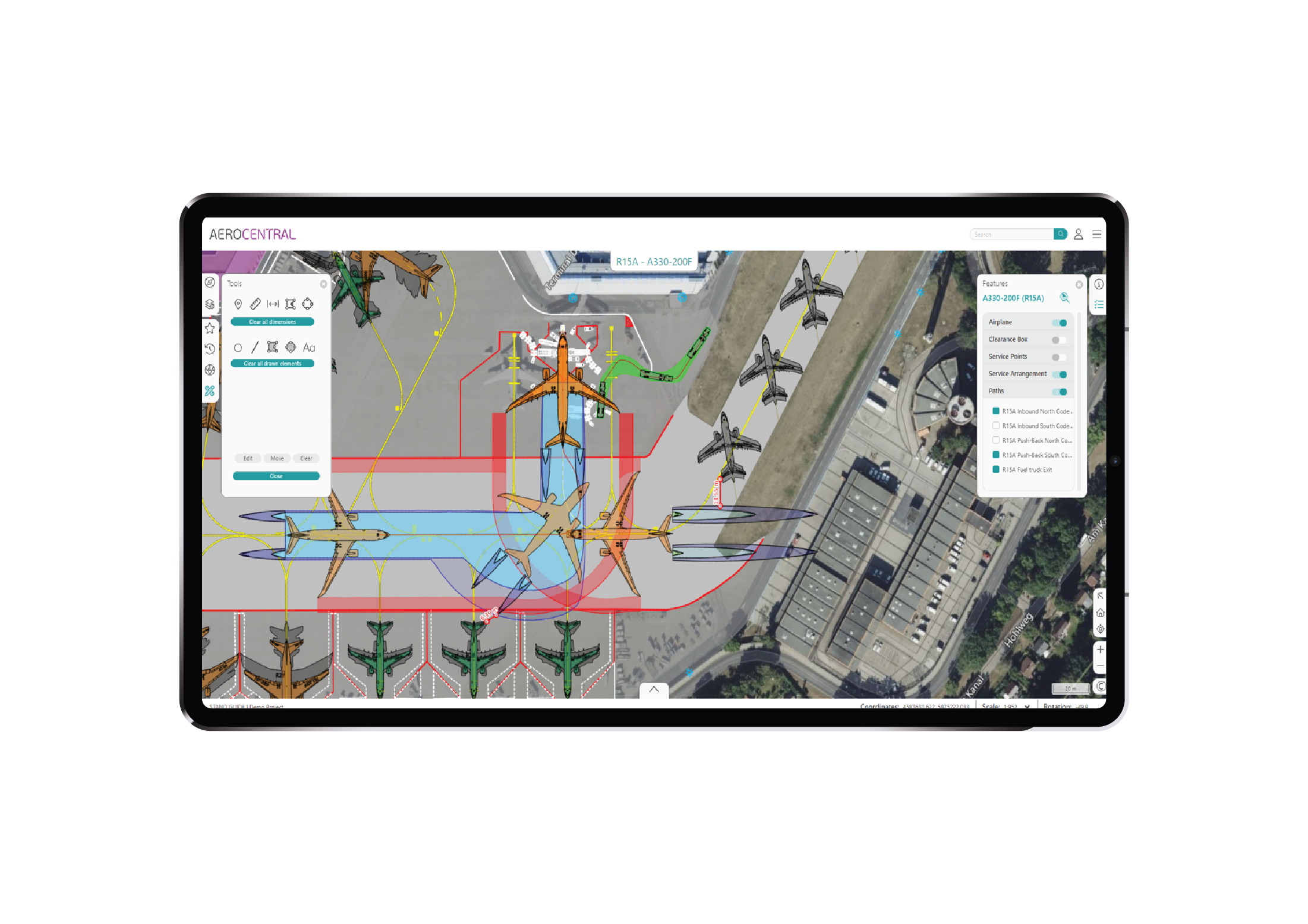
Figure 3. The AeroCENTRAL Stand Guide application
“As you go through the navigation process to get to where you want to work, the map changes automatically, and it’s always automatically and logically filtering all the information. You’re never searching for information, it’s presented to you in context.” Goodworth emphasizes that operations staff don’t have to reinvent any information to populate AeroCENTRAL—they can link straight through to information that already exists. “There is virtually no limit to the amount of information that can be added, it’s possible to be very granular.” AeroCENTRAL can also connect to external GIS, Airport Operational Databases (AODB) or Safety Management Systems (SMS).
Yet while it is possible to add or link any amount of operational information to AeroCENTRAL Stand Guide, certain information, for example, stand coordinates, ground slopes, stand widths and lengths or passenger boarding bridge characteristics and limitations are all retrieved from the imported AviPLAN models. “Transferring the models that’ve been created in AviPLAN into AeroCENTRAL Stand Guide allows users to view the aircraft that’s being serviced, expected service vehicle positions and the passenger boarding bridge in parked or docked position,” says Goodworth. “You can also add static path simulations, for example lead-in and pushback, as well as videos from AviPLAN showing those procedures in motion. These types of simulation results often never leave the design room, but they can be very helpful to operational staff.”
While Goodworth notes that AviPLAN data is not needed to use AeroCENTRAL Stand Guide, and that the application can be used with only map and textual information, including technical models created in AviPLAN brings the added advantage of a visual element, to give context to the text. Goodworth continues, “AviPLAN has been around for three decades and it is the industry standard for airside planning and design. There are thousands of users around the world. Many airports have valuable AviPLAN-generated data locked away on local hard drives and in technical drawings. AeroCENTRAL Stand Guide gives new, extended life to all the valuable information that’s been created within AviPLAN.”

Figure 4. The AeroCENTRAL Specifications application
Bernard notes the value of AeroCENTRAL, and its applications Stand Guide and Specifications, in supporting airport planners and designers too. “When designing a parking position, a designer is primarily interested in the geometry and making sure everything works on that side. But it’s also important to know how operations work, so you can consider all of that in the design. It can be a difficult task for a planner or designer to get the right information, and the right amount of it, for the planning process. But with AeroCENTRAL Stand Guide, that operational information is all in one place, so it can be easily shared. And those doing the planning can then also give the right information back to operations in a timely way” adds Goodworth.