Optimize En Route Airspace Structure
AirTOP En Route is geared towards agencies and airports to simulate the complexity and capacity of upper airspace, and model necessary separation procedures. It provides realistic en route simulations and supports all key en route structures and controller tasks, as well as static or dynamic restrictions related to them.
Assess en route airspace metrics by modeling and evaluating air traffic control procedures in high fidelity.
Platform Compatibility
Platform Requirements
Java 17 64-bits
System Requirements
Full support for 64-bit operating systems
Windows® 8 or later
MacOS® X 10 or later
Linux kernel 2.6 or later (e.g. Ubuntu, Fedora, RHEL)
English
What Makes AirTOP En Route Unique
Boost productivity
Model air traffic and control procedures (including conflict detection/resolution, letters of agreement, and tactical re-routing), and assess controller workload.
Collect and manage data easily
Create easy-to-use, high-fidelity airspace and air traffic models for use in capacity studies, re-sectorization projects, reorganization of routes, or implementation of free-route or Reduced Vertical Separation Minima (RVSM) airspaces.
Drive business intelligence
Measure capacity, delays, and economic or environmental performance.
Seamless integration
A model created in En Route can be seamlessly linked to the TMA/TRACON, Flow Management and Airside Aircraft modules.
Features
Scenario Definition and Modeling
With its forward-thinking approach, AirTOP allows scenario editing, simulation execution, debugging, reporting and analysis through one single sophisticated interface which includes highly interactive 2D maps and 3D views.
- Static data modeling such as waypoints, routes, ATC sectors and airspace
- Create en route traffic simulation easily
- Simulate controller workload roles
- Export data and visualize results
Explore Features
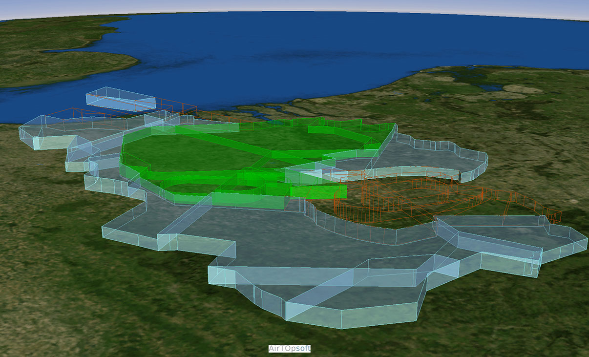
Static Airspace Data Modeling
AirTOP En Route supports the modeling of static airspace data such as waypoints, ATS routes with altitude and/or speed restriction per segment direction, ATC sectors and airspace. Elementary or collapsed ATC Sectors, optionally with their respective capacities including Area Control Centers (ACC), regional/sub-regional airspaces (FIR, NAS, ECAC), military airspace and FLAS areas, can also be modeled.
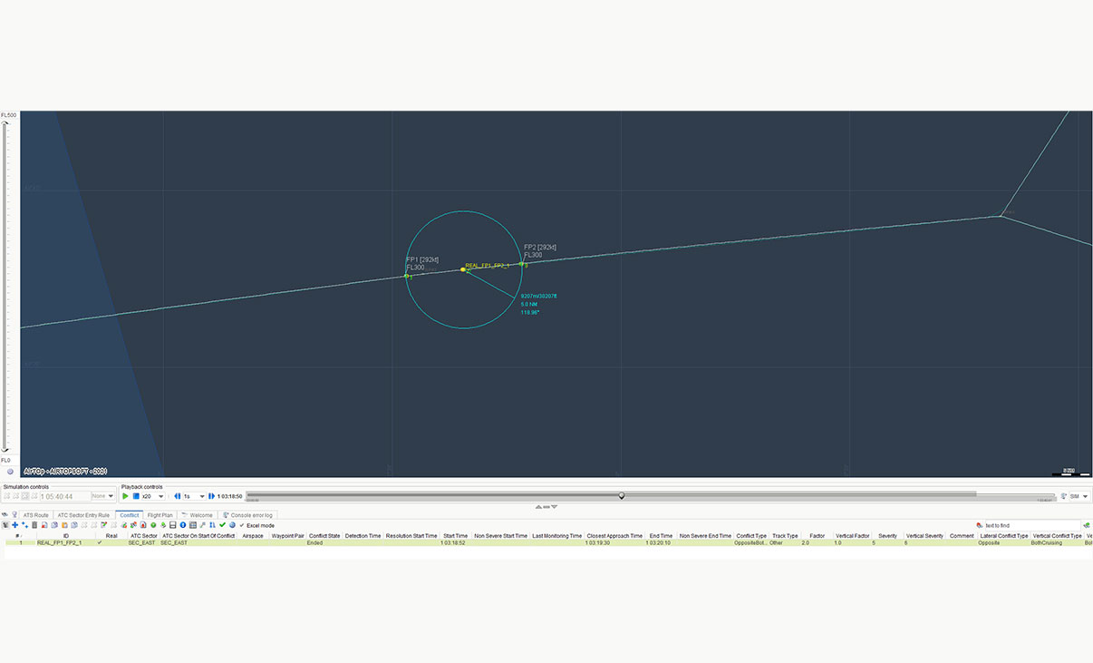
Conflict Detection and Resolution Modeling
Conflict detection and resolution can be modeled in AirTOP’s En Route module using a user-editable conflict resolution rule base. The rule base includes resolution strategies (stop climb/descent, vector parallel/behind, cruise level change, earlier descent, follow at the same speed/descent rate, shortcut, etc.) that can be customized by the user, taking into account the nature of the potential conflicts detected by the simulated radar controllers (conflict type, the relative position of aircraft, the destination of aircraft, routing merging or not, distance to TOD, resolution maneuver feasible in the sector, etc.).
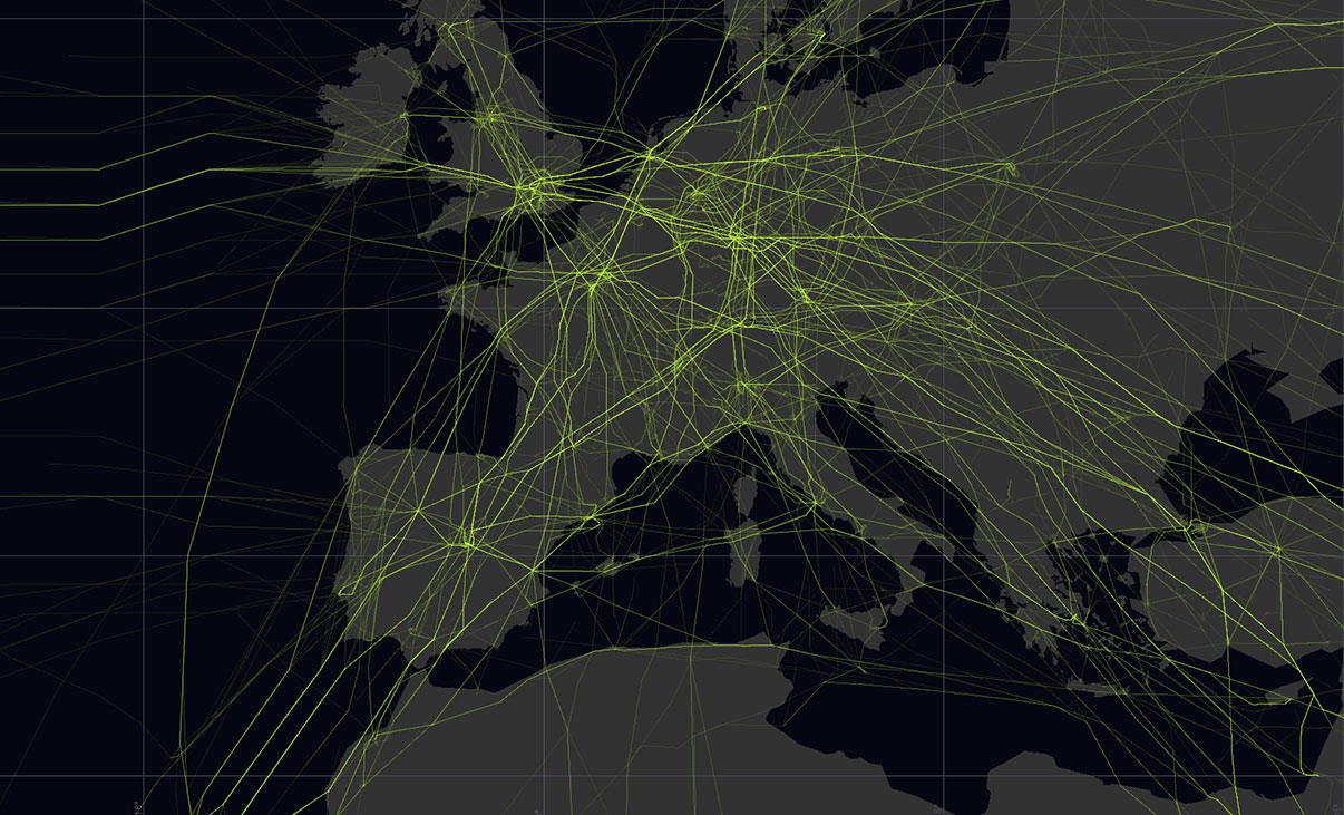
Efficient Traffic Routing
The routing concept in AirTOP En Route provides an easy way to quickly create en route traffic simulation, avoiding duplication of traffic paths for aircraft flying to or from the same destination. The module supports the creation of flight routes as a combination of waypoints and airways/ATS routes. The ATS routes concept facilitates the creation of bi-directional airways, with opened flight levels specified by segment.
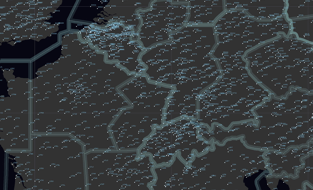
Data Import
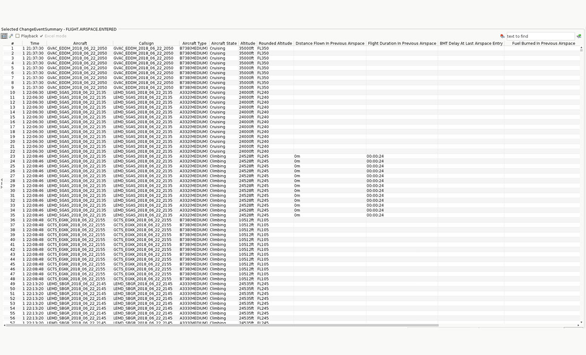
Waypoints, ATS routes with altitude and/or speed restriction per segment direction, ATC sectors and dynamic sectorization, FLAS areas, radar controller tasks and dynamic allocation of a radar controller to a sector, can all be easily defined in AirTOP by simply clicking on the map or via the adjacent information display. They can also be completely or partially imported from external data sources, such as GASEL, AIXM, or using ad-hoc importers.
Detailed Controller Workload Modeling
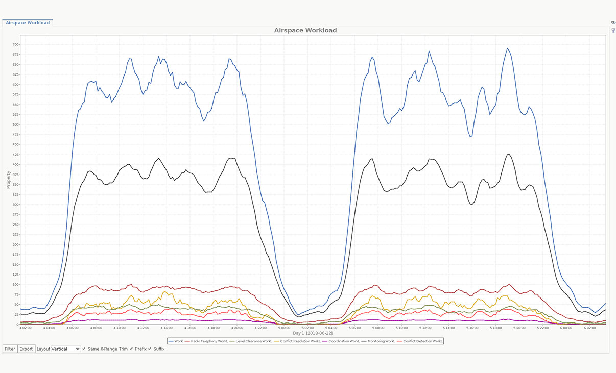
AirTOP dynamically simulates controller workload for all controller roles. The workload model can take into account any event and associate a work duration with it. AirTOP also considers flight monitoring activities that can be further specified depending on flight phases (climbing, cruising, in approach, holding, etc.). The work duration associated with event handling (sector entry in climbing, altitude change clearance, etc.) can be split into generic user-defined activities (radio com, monitoring, conflict resolution, etc.). Duration spent per event and per activity can then be logged per rolling hour.
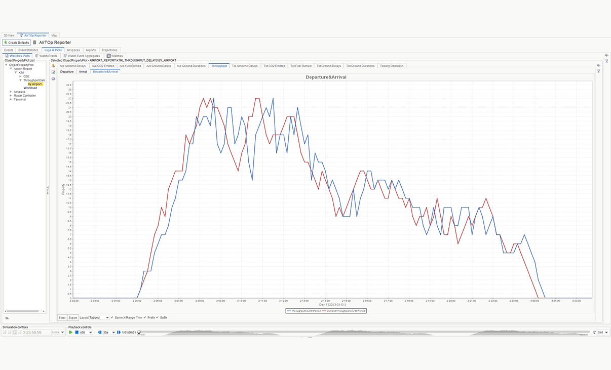
AirTOP Reporter
The AirTOP Reporter allows users to quickly retrieve, visualize and aggregate simulation results. It generates plots and tables exportable to spreadsheets or images to be used in external analysis and reporting tools.
Data Export
Built-in statistics per sector, flight, airport, or runway can be easily queried and exported (spreadsheet files, SQL databases) from AirTOP. The result of multiple simulation runs (that may include user-defined random variations) can be aggregated to provide statistically significant results.
Licensing Options
Transoft offers a range of licensing options to help small, sole proprietorships right on up to the largest multinational organizations meet their transportation design and analysis needs.
Network License
A Network license allows everyone within an office location to access the software from the company server with one person concurrently using at a time. Network licenses are not tied to a particular workstation or user. Multiple Network license seats can be purchased, and a license server keeps track of how many licenses are in use at one time. When Transoft’s software on a Network license starts, it first checks to see if a Network license is available to use. If so, a license is then checked out from the pool of licenses. When a user exits the application, the license gets checked back into the pool making it available to other users.
Transoft Support
We take pride in delivering complete customer satisfaction. Get help with products, downloads, technical support, and more.
My Transoft Portal
Transoft's product enhancements are periodically released to provide access to new features, fixes, and security updates. For many products, you can find these updates and download them directly from My Transoft Portal.
Software License Agreement
For information on terms and conditions detailing the usage of our software, please refer to Transoft’s Software License Agreement (SLA).
Software FAQ
Search our extensive product knowledgebase that address some of the most frequently asked questions regarding Transoft ‘s software.
Help Desk
Find answers to your issues on a variety of topics or request Technical Support. Get help with downloading and installing your software, managing your account, product compatibility and much more.
Licensing Options
Transoft offers a range of licensing options to help small, sole proprietorships right on up to the largest multinational organizations meet their transportation design and analysis needs.
Project Support Services
Need assistance with custom drawings and content creation related to your project design work? Transoft’s team of consultants can help. We deliver fast and helpful services for clients requesting additional assistance with drawings and simulations related to their project design work.
Training
We offer many excellent opportunities for you to take a more interactive approach in learning about our solutions. From webinars to how to videos, find what you need here.
AirTOP En Route Videos
Request a Quote
Thank you for your interest in AirTOP. Fill out the form to receive information on purchasing and licensing options or if you have questions in general about the software.
On business days, you can expect a response within 24 hours of your request.